Vanishing Acts: The Forgotten Backcountry Shelters America Left Behind
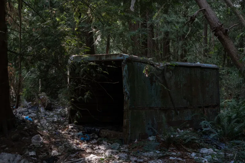
Somewhere in the Bitterroot Wilderness, there's a three-sided log shelter that doesn't appear on any current USFS topo. No trail marker points toward it. No permit system acknowledges its existence. A weathered tin roof sags under decades of snowpack, and the interior smells like pine resin, pack rat nests, and something older—maybe the ghost of a 1940s fire crew who scratched their initials into the back wall before heading home to a country at war.
These places are everywhere, if you know how to look.
Across the American backcountry—from the Cascades to the Smokies, from the high desert plateaus of the Colorado Plateau to the boggy spruce forests of Maine—there's a parallel infrastructure of forgotten shelters slowly dissolving back into the landscape. Fire lookout towers with collapsed staircases. Stone huts built by the Civilian Conservation Corps that nobody has officially maintained since Eisenhower was president. Emergency bivouac cabins stripped from USGS maps during the 1990s wilderness designation debates. They're not secrets exactly, but they're not exactly public knowledge either.
And for the right kind of trekker, they're absolutely worth chasing.
Who Built These Things, and Why
The golden era of backcountry infrastructure in the United States ran roughly from the 1930s through the early 1970s. The CCC alone constructed thousands of miles of trail, dozens of ranger stations, and hundreds of fire lookouts across the national forests and parks. Many of those structures were designed to be permanent—built from local stone, old-growth timber, and a kind of institutional optimism that's hard to imagine today.
Fire lookout towers were the most ambitious of the bunch. At the movement's peak, the Forest Service operated over 8,000 staffed lookouts across the country. These weren't flimsy platforms—they were genuine structures with sleeping quarters, wood stoves, Osborne Fire Finders, and sometimes even tiny gardens planted by the lookouts who lived there through long summer seasons. Writers like Jack Kerouac and Gary Snyder famously worked fire lookout stints, and the solitary, sky-high lifestyle became something of a countercultural touchstone.
The emergency shelter network was a different animal entirely. These smaller structures—lean-tos, Adirondack-style three-sided shelters, and fully enclosed bivouac cabins—were built to keep people alive when the weather turned nasty. In the White Mountains of New Hampshire, the AMC hut system grew out of exactly this logic. In the Sierra, the Forest Service maintained small cache cabins stocked with basic supplies. In Alaska, the BLM still operates a network of public-use cabins that feel like time capsules from a more self-reliant era of backcountry travel.
The Quiet Erasure
Here's where things get interesting—and a little murky.
Starting in the 1970s and accelerating through the 1990s, a combination of budget constraints, changing wilderness management philosophies, and evolving liability concerns led agencies to quietly decommission hundreds of backcountry structures. Some were torn down. Others were simply left to deteriorate, with the expectation that nature would handle the cleanup eventually. And a surprising number were deliberately removed from official maps without any public announcement.
The reasoning varied. Wilderness Act purists argued that man-made structures compromised the "untrammeled" character of designated wilderness areas. Risk managers worried about the liability exposure of maintaining aging infrastructure in remote locations. Budget officers looked at the cost of helicopter-ferrying materials to high-elevation sites and made the math work by eliminating line items entirely.
What got lost in that calculus was institutional memory. When a shelter disappears from a map, the knowledge of its location doesn't automatically vanish—it just becomes informal, passed between rangers and long-distance hikers and local mountaineers in the form of whispered recommendations and hand-drawn sketches. Which is, honestly, how BomjTrek thrives. The trail doesn't end where the map does.
What Trekkers Actually Find
The experience of discovering one of these forgotten structures is genuinely hard to describe to someone who hasn't done it.
You're usually several miles past the last maintained trail, following a faint use path through brush that suggests regular historical traffic even if nobody's come this way in years. Then the trees thin, or a drainage bends, and there it is—a structure that shouldn't exist according to anything you downloaded before leaving the trailhead. The geometry of it is jarring. Human right angles in a world that's gone entirely back to curves.
Inside, if you're lucky, you find artifacts: a rusted tin of matches, a logbook with entries spanning four decades, a hand-lettered sign listing distances to landmarks that have since been renamed or rerouted. Sometimes there's a stove that still works if you coax it. Sometimes the roof has given way entirely and the floor is a carpet of moss and debris.
The historical texture is the real draw. A shelter built by a fire crew in 1938 carries the fingerprints of people who understood the backcountry as a working landscape, not a recreational amenity. The construction choices—the placement relative to prevailing winds, the choice of stone versus timber, the orientation of the door—all reflect a practical intelligence that modern hikers rarely develop because we don't have to.
The Ethics of Ghost Shelters
Let's be real about the complications here.
Some of these structures are genuinely dangerous. Roof collapses, rotted floor joists, unstable chimney stacks—the risks are real, and the fact that a shelter appears on a 1955 USGS quad doesn't mean it's safe to use in 2024. Knowing the difference between a structurally sound forgotten cabin and a genuinely hazardous ruin requires some experience and honest self-assessment.
There's also a Leave No Trace dimension worth thinking through. Using a deteriorating structure—especially building a fire in a compromised firebox or adding to the debris load inside—can accelerate the decay process. The best approach is usually to document what you find, take nothing, and leave the place as close to how you found it as possible. These sites are more valuable as historical artifacts than as functional campsites.
And then there's the question of whether to share locations publicly. This one's genuinely contested in the trekking community. Some folks argue that wider knowledge brings more eyes and more stewardship pressure. Others point out that fragile historical sites have a way of deteriorating rapidly once they hit the Instagram circuit. There's no clean answer, but erring toward discretion feels right for the most vulnerable structures.
Finding Your Own Ghost Shelter
If you want to start hunting these places, the research trail is actually pretty accessible. Historical USGS topographic maps—available through the USGS TopoView database—often show structures that have since been removed from current editions. The Forest Service maintains historical records in regional offices that are technically public, though navigating the request process takes patience. Old hiking guidebooks from the 1960s and 70s frequently reference shelters that have since been decommissioned.
Talk to long-time locals. Rangers who've worked the same district for twenty or thirty years are walking encyclopedias of informal infrastructure knowledge, and many of them are quietly proud of the historical texture their territories contain. Buy them coffee. Ask good questions. Listen more than you talk.
Most importantly, go slow when you get out there. These structures don't announce themselves. They require the kind of attention that the backcountry rewards when you stop moving fast enough to actually see what's around you.
The trail ends. Then the real looking begins.